
Texas Eco-Regions
Rolling Plainsback to Eco-Regions Map
Elevation
Elevations range from 900 feet in the northeast corner to 4,000 feet in the upper northwest arm of the Rolling Plains. The majority of the Rolling Plains is between 1,000 and 3,000 feet above sea-level.
Precipitation
Rainfall amounts average 22 to 30 inches per year.
Topography
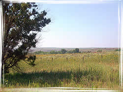
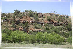
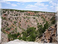
Part of the Great Plains of the central United States, the topography is characterized as being rough terrain. The bottomland areas of the east contain more riparian zones than those in the western Rolling Plains.
Soils
Most of the soils are considered neutral to alkaline. Forming under grasslands they have a high fertility, making them sought after for crop production. These soils are found ranging from the lower to the upper portions of the Rolling Plains.
Vegetation Description
Native vegetation varies between the northern and southern halves of the Rolling Plains Region. The northern portion contains black willow, plains cottonwood, redberry juniper, and shin oak. On the banks of Canadian River, salt cedars are dominant accompanied by honey mesquite and willows. The southern portion contains pecan, persimmon, netleaf hackberry, live oak, sugarberry, Texas red oak, gum bumelia, and Ashe juniper. Both portions share honey mesquite, plains cottonwood, and western soapberry. Shrubs found in this eco-region include species of wild cherry and plum, as well as sages. The Rolling Plains contain many of the typical plains grasses: buffalograss, hairy, blue, and sideoats grama, big bluestem, indiangrass, Canada wildrye and Texas bluegrass.
Impacts of Fire
Fire historically had an impact on the Rolling Plains region, by suppressing woody species and favoring open grasslands. Fire kept resprouting honey mesquite and juniper populations at low densities. Even though there are no tree ring studies to document fire frequency, historically this area is assumed to have had a fire occurrence every 5 to 10 years. This frequency created the low populations of woody species observed by early explorers to the region. Following settlement, fires were suppressed and improper grazing occurred. Overgrazing by livestock weakened the native grasses, removed fuel needed for a burn and set the stage for aggressive woody plant species to increase. Droughts accelerated the process. Some of the woody plants were natives that increased while others were not native to the sites. Cattle and wildlife helped to spread some of these plants as most of the seeds pass undigested in droppings. Mesquite beans, which are high in protein, are relished by cattle, especially during drought. Range managers are now faced with many areas that have crossed thresholds so that fire is no longer an effective tool. In those cases, chemical and mechanical treatments are the only options. Integrated treatments of several different brush management methods over time are recommended. Urbanization and improper grazing limits the opportunities to use fire as a management tool. However, fragmentation and urbanization in this area generally has been slow.
Historical Information
This region was historically comprised of numerous large ranch holdings, although that number is dwindling as a number of the large landholdings are being sub-divided into smaller plots.
Other
The income producing opportunities supported by this eco-region include ranching (cattle), cotton, wheat, sorghum, rangeland, oil, and game hunting.