Texas Eco-Regions
Edwards Plateauback to Eco-Regions Map
Elevation
Elevation ranges from 600 feet above sea level in the eastern canyons to 3,000 feet above sea level in the ridges of the central and western regions.
Precipitation
Because of the elevation drop off at the edge of the Edwards Plateau as well as its location between the dry western plains and the moist prairies and woods to the east, average rainfall varies widely from 23 inches per year to 35 inches per year.
Topography
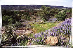
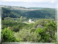
The central and northern portions of the Edwards Plateau as well as the upland ridges of the southern and eastern portions contain round, often rolling hills.
Soils
Most of the Edwards Plateau contains mottled yellowish clay to clay loam surface soil which quickly turns into rocky clay or solid limestone rock layers beneath the surface. Erosion has left most of the region with very shallow soils of less than 10 inches.
Vegetation Description
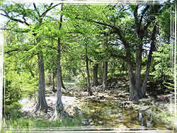
The Edwards Plateau is characterized by a combination of tall, medium and short grasses, often intermixed into a woodland or forest setting with hardwood trees such as escarpment live oak, Texas oak, honey mesquite and with coniferous Ashe juniper. Protective canyons, especially on the eastern and southern portions of the plateau, provide for a great diversity of other hardwood species such as Texas madrone, escarpment black cherry, Texas mountain-laurel, Mexican plum, Carolina basswood, lacey oak, and bigtooth maple. Springs and creeks found in these canyons are typically lined with baldcypress, sycamore, and black willow.
Impacts of Fire
Prior to heavy settlement, fire played a major role in shaping the vegetation on the Edwards Plateau. Fire occurred on the majority of the land every 4-7 years. During this interval, Ashe juniper was kept out of most uplands by fire and dense grass competition. Other trees such as escarpment live oak and honey mesquite were kept more isolated among the grasses. In these cases, older trees or groups of trees could either withstand wildfires or inhibit their spread because they are generally more fire resistant than grasses. Concentrated livestock grazing which reduced the fire carrying grasses, allowed trees, especially Ashe juniper to expand into the open areas. Protected canyons and moist, north facing slopes reduced the number of damaging fires which allowed many trees to persist prior to human settlement.
Historical Information
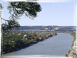
Thought of as the southern extension of the Great Plains, bison were known to frequent the Edwards Plateau. Their migration in great numbers undoubtedly affected the landscape, plant communities, and the cultures of early human inhabitants. Anglo settlement brought German farming communities, and adventurous livestock ranchers which have been since identified with Texas. Currently, this region of Texas is being shaped by tourists and future landowners drawn to the clear running streams, hilltop vistas, and historic buildings made of limestone with exceptional early craftsmanship.
Other
The Edwards Plateau region near Stonewall and Fredericksburg has provided settlers and tourists with high quality peach and vegetable crops. Recently, many of the hilly slopes have provided good growing conditions for grapes. Because of this, wineries have become unique and attractive tourist destinations in the Edwards Plateau.